NWS graphic
UPDATED 9:30 A.M.
Poplar Bluff, Twin Rivers and Neelyville schools will release early today for severe weather.
The goal for Poplar Bluff is to begin a staggered release at 11:30 a.m. and have all students home by 1:30-1:45 p.m., ahead of potentially severe weather this afternoon, according to the district.
Specific release times for campuses can be found on the district website and social media, said Dr. Scott Dill, superintendent.
“This thing is going to hit us it looks like right in the middle of our afternoon transportation cycle,” Dill said. “Out of an abundance of caution, having looked at this, discussed it with EMS for the county, we feel its in the best interest of our students to get everybody home in advance of this potentially damaging storm.”
The last buses will pick students up from their campuses at 12:45 p.m., Dill said.
“The hope is to have everyone home by 1:30-1:45,” he said.
Twin Rivers car riders will be released at 11:15 a.m. and bus riders at 11:30 a.m., according to the district.
Neelyville schools will dismiss at 1 p.m. Bus riders are expected to be home by around 2:15 p.m., according to school officials.
8:30 a.m. UPDATE
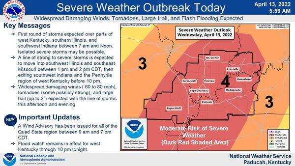
The potential for severe weather is expected to hit the Carter and Ripley counties areas by around 1 p.m. according to the National Weather Service.
A significant storm system is expected to cross Southeast Missouri between 1-4 p.m. today, said Greg Meffert, NWS lead forecaster. Carter and Ripley counties sit at the farthest west area of the Paducah, Kentucky, office’s region and will see impacts first, he said.
The system may reach Butler County by around 2 p.m., according to current forecast predictions.
“There’s the potential for all types of severe weather, whether it be damaging wind gusts, large hail and even a couple tornadoes,” said Meffert. “The good news is the window is fairly short. In any one spot, the threats probably going to be an hour or so.”
Damaging winds of 60 to 70 mph winds or higher, large hail up to two inches, and tornadoes are all possible, the NWS has reported. Widespread damaging straight-line winds are expected.
Meffert also warned of torrential downpours during this timeframe and the threat of localized flash flooding.
A wind advisory is also in effect for wind gusts up to 40 mph outside of storms through 7 p.m., according to the NWS.
The Storm Prediction Center has the entire area at a Moderate Risk of Severe Weather.
