This National Weather Service graphic shows snowfall predictions.
UPDATE 10 A.M. Sunday
The National Weather Service has upgraded the to a winter storm warning, and is advising against travel in the region tonight through Tuesday morning.
“With continued model consistency, we have enough confidence to upgrade the Winter Storm Watch to a Winter Storm Warning for the entire forecast area,” the NWS reported. “The warning is in effect from 6 PM CST this evening until 6 AM CST Tuesday morning. The snow will likely begin
across southern and western portions of the area late this afternoon, then spread northeast across the area tonight.”
This first round of snow is forecast to bring 1 to 2 inches of snow to most of the area by daybreak Monday.
“A relative lull in the activity is expected from late tonight into Monday morning before the second band of potentially heavier snow arrives Monday afternoon and evening,” meteorologists say. “This second round of snow has the potential to produce snowfall rates of 1 inch per hour at times. And with gusty north winds, blowing and drifting of snow will create hazardous travel conditions.”
Total snow accumulation is forecast to range from 3 to locally 6 inches (northwest half) up to 5 to locally 9 inches (southeast half). The heavier totals appear more likely across the southeastern half of the area where snow during the second round is forecast to be heavier.
“Still, adjustments to those numbers are likely as we draw closer to the event,” the NWS said.
The snow will taper off from west to east Monday night, but the Tuesday morning commute is likely to be just as hazardous as low temperatures in the single digits offer little to no chance for chemicals to work their magic on roadways.
“Highs today and Monday will remain in the teens across most of the forecast area. Even after the Wind Chill Advisory expires, it`s still going to be brutally cold with wind chill readings below zero in many locations,” the NWS reports. “This will make for a dangerous situation if you choose
to travel during the storm and end up getting stranded in the snow. Thus, travel is not advised tonight through Tuesday morning.”
5 pm Saturday
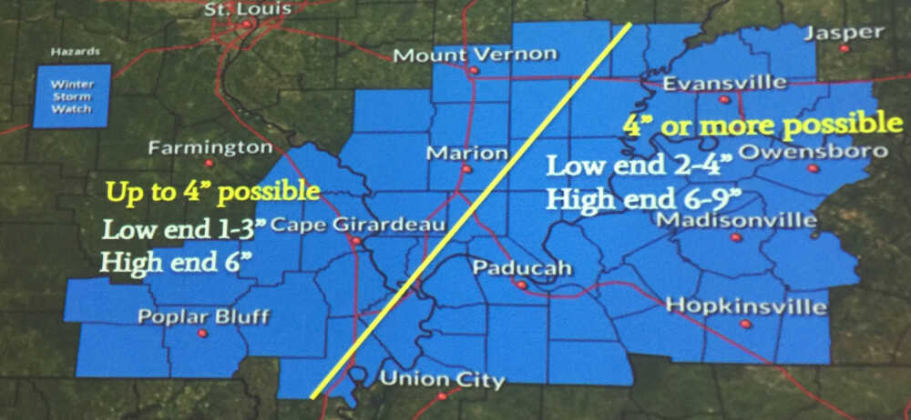
Snow predictions for Carter, Ripley, Butler, Wayne and Stoddard counties range from one to six inches for a weather event moving into the area Sunday afternoon, according to information shared by the National Weather Service.
A winter storm watch is in effect for the area from 6 p.m. Sunday through 6 a.m. Tuesday. A wind chill advisory is also in place from midnight to noon Sunday, with wind chill temperatures of -5 to -15 expected.
Another weather event is expected Wednesday, but the NWS said it is difficult to predict what that could bring.
The NWS held a conference call Saturday afternoon with approximately 200 government officials, first responders and others across Missouri, Arkansas, Illinois and Kentucky. Poplar Bluff and Butler County officials participated in the call.
Snowfall is expected to start Sunday afternoon before stopping briefly Monday morning, said meteorologist Chris Noles.
The heaviest snowfall will come Monday afternoon and evening, Noles explained.
“The main system comes out Monday afternoon, and will provide heavier snow rates, especially across the eastern area where we're more concerned about hitting winter storm warning criteria,” he said.
The models are still shifting just a little bit, Noles explained, but areas to the east are expected to see higher snowfall amounts than Southeast Missouri. Anywhere from two to nine inches are predicted for portions of Illinois and Kentucky.
“The bottom line is, is I think all areas will be impacted,” he said. “I think for all areas, we're looking at impacts, and that's what's most important as far as messaging at this time.”
This system should be clear by Tuesday morning.
“We’ve really been trying to gauge the snow to liquid ratio with this event. That'll play a role in the amounts that we receive,” he said. “The air is so cold, we've been trending toward … higher snowfall totals, and everything that falls, as you know, is going to stick immediately. So I would say the low-end values are less likely than the higher end values.”
