UPDATED, Saturday 2: 50 p.m.
By MICHELLE FRIEDRICH
The Poplar Bluff area escaped the wintery weather that was predicted to hit on Friday.

Officials from several agencies in and around Poplar Bluff meet for a conference call Friday morning with the National Weather Service to learn of the weather system's expected impact.
DAILY AMERICAN REPUBLIC, Paul Davis
The area received less than an inch of a sleet/snow mixture, according to Deanna Lindstrom, a meteorologist National Weather Service at Paducah, Ky.
“Then, it all changed over to rain, which is what its continuing to do now,” Lindstrom said.
The rain, she said, was expected to continue “off and on” throughout the evening and overnight hours Saturday, with “more scattered rain tomorrow, then ending tomorrow night.”
Lindstrom said the weather will be dry and cold for the first few days of next week, followed by a chance of precipitation at the end of the week.
“It will warm up again at the end of the week,” she said.
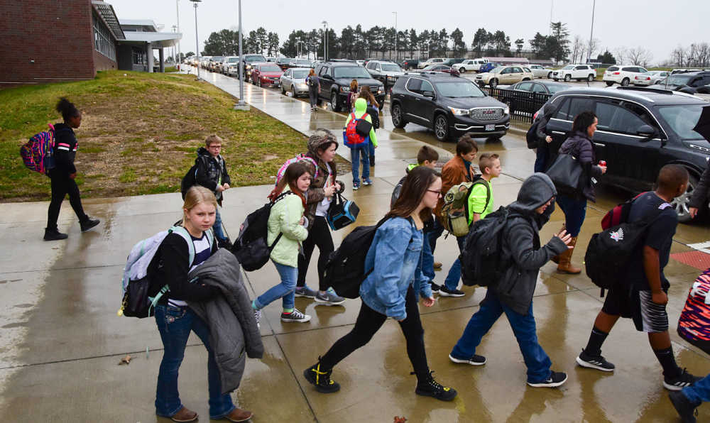
Poplar Bluff Middle School students are dismissed early Friday as sleet settles over the region.
DAILY AMERICAN REPUBLIC, Paul Davis
from earlier
UPDATED NOON
By DONNA FARLEY
Associate Editor
Some icing and freezing rain is predicted for Butler County and the surrounding region in late afternoon and early evening Friday according to officials who participated in an 11 a.m. phone conference with the National Weather Service. The weather is expected to clear by Saturday morning.
Neelyville schools will close at 1 p.m. and Puxico schools at 12:30. Twin Rivers schools are closing at noon. Poplar Bluff R-I closings: 1 p.m. middle school, junior high and high school; 2 p.m. kindergarten center; 2:15 p.m. for all elementary schools.
“This was just some unexpected stuff that even yesterday, forecast didn’t really tell us about,” explained Craig Meador with the Poplar Bluff Severe Weather Response Team. “It’s some unexpected precipitation moving from the west. … Right now, it’s actually freezing rain.
“In the next few hours, late afternoon to evening we could see some icing conditions due to some freezing rain that’s moving our way.”
There is a chance for .05-inches of accumulation of freezing rain in Southeast Missouri, said Ashley Ravenscraft, a meteorologist with the National Weather Service. While that may not sound like a lot, she cautioned it doesn’t take much accumulation for roads to deteriorate.
There is the potential for Wayne County and areas north to see more winter precipitation, Meador said, adding that area is under a winter storm warning.
“For tonight, we’re going to see some snow accumulation,” Meador continued. “It’s not going to cause a huge impact, because it’s going to be gone by tomorrow morning.
“The temperature by 9 or 10 (a.m.) should get things back to just rain.”
About 1-3 inches of snow are possible overnight, he said.
Snowfall in southern Butler County is expected to be about 1-inch, Ravenscraft said, and 2.5-3 inches in the northern part of the county.
Attending the meeting were representatives from area schools, both hospitals, the sheriff’s department, Poplar Bluff city council and street department, Butler County, the state and the Missouri State Highway Patrol.
Community partners will continue to follow the situation, said Robbie Myers, Butler County Emergency Management Agency director.
UPDATED 10:29 a.m.
Twin Rivers R-10 is closing at noon today. Additional school closings will be added as information becomes available.
Northside Nutrition Center in Poplar Bluff's dining room is closed today but will be delivering meals.
Poplar Bluff R-I schools to dismiss at 1:00.
Doniphan R-I School basketball game against Naylor has been cancelled.
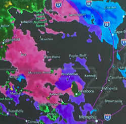
The National Weather Service has issued the following announced for Carter, Ripley, Butler, Stoddard, and Scott counties including the cities of Van Buren, Doniphan, Poplar Bluff, Bloomfield, and Sikeston:
Accumulating snow late this afternoon into early Saturday. An approaching storm system will bring a period of wintry precipitation to the region starting today and continuing into tonight and early Saturday morning. While mixed precipitation is possible at the onset, a transition to mainly snow is expected through most of tonight when the heaviest snow accumulations are forecast. A transition to mainly rain from south to north is forecast by Saturday morning as temperatures warm above freezing.
A winter weather advisory is now in effect until noon Saturday. Mixed precipitation expected. Total snow accumulations of 1 to 3 inches in the Poplar Bluff area and ice accumulations of around one-tenth of an inch are expected.
A Winter Weather Advisory means that periods of snow, sleet or freezing rain will cause travel difficulties. Expect slippery roads and limited visibilities, and use caution while driving. The latest road conditions for the state you are calling from can be obtained by calling 5 1 1.